
- Rodrigues boasts a mild tropical maritime climate year-round, with consistent trade winds providing a refreshing breeze.
While Rodrigues enjoys a generally pleasant climate, it is susceptible to extreme weather events like cyclones, droughts, and floods. These events can cause damage to infrastructure and disrupt economic and social activity on the island.
Read More..
- + Climate of Rodrigues (MMS)
- + Forecast Bulletin - Rodrigues (MMS)
- + Cyclone Warning Bulletin (MMS)
- + Sunrise Sunset Moonrise Moonset Tides (MMS)
Temperatures
- Average summer temperature: 25.9°C
- Average winter temperature: 22.3°C
- Seasonal variation: Winters are slightly cooler than summers.
- Hottest months: December to April
- Coolest months: July to September
Rainfall
- Wettest months: February
- Driest months: October
- Long-term average:
- The long-term annual mean rainfall (1961-2007) is 1116 mm.
- The mean summer rainfall is 729 mm which is equivalent to 65% of the annual total rainfall.
- Winter rainfall is only 392 mm.
Sunshine
- The island enjoys an abundance of sunshine, averaging around 8.9 hours daily.
Wind
- Average wind speed is a moderate 18.1 km/h at Pointe Canon.

Historical data from Rodrigues on temperature, precipitation, and sea level rise indicate significant changes over time.
Increasing Temperatures
Changing Rainfall Patterns
Between 1961 and 2014, the average maximum temperature rose by 0.023°C, and the average minimum temperature increased by 0.016°C (TNC, 2016). Future projections for climate change from 2051 to 2070 predict temperature rises ranging from 0.9°C to 1.4°C and from 1.3°C to 1.6°C under two different climate scenarios, compared to the baseline period of 1996-2005 (TNC, 2016).
Temperature Projections for Rodrigues for RCP 4.5 and RCP 8.5 (source: TNC, 2016)

Rodrigues, an island with limited water resources, has experienced a decline in rainfall compared to data from the 1960s. Rainfall projections from models are intricate, as they do not show a distinct long-term trend. Nevertheless, seasonal variations are pronounced, with expected reductions in rainfall during the summer months and probable increases during the transitional months of May and October.
Precipitation Projection for Rodrigues for RCP 4.5 and RCP 8.5 source: TNC, 2016
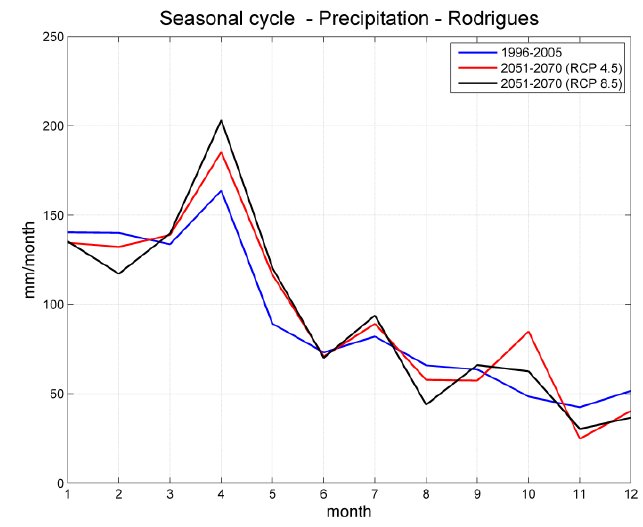
Projections for RCP 4.5 and RCP 8.5 scenarios, does not show significant variation with respect to the present rainfall pattern.
Increased Frequency of Extreme Weather Events
Rodrigues, located in the cyclone-prone region of the Indian Ocean, faces an increased risk of intense tropical cyclones as climate change progresses.
These cyclonic events can cause extensive damage to infrastructure, agriculture, and ecosystems, leading to hazards such as landslides, soil erosion, and post-cyclone water contamination. The island's coastal regions may also face increased vulnerability to storm surges, resulting in damage to infrastructure and coastal ecosystems.
Rodrigues relies heavily on the tourism industry, attracting visitors with its natural beauty and cultural richness. The increased frequency of extreme weather events, such as intense tropical cyclones, can disrupt tourism activities, damage infrastructure, and undermine the economy, causing loss of revenue and potential job losses.
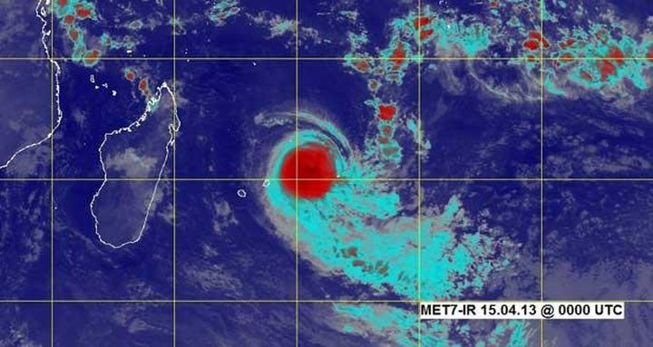
TC Imelda, April 2013 Sea Level Rise (SLR) and Its Impacts
Sea level rise, a direct consequence of global warming, is primarily attributed to the thermal expansion of oceans and the melting of ice sheets and glaciers. The Intergovernmental Panel on Climate Change (IPCC) predicts an average global sea level rise between 0.26 to 0.77 meters by the end of the 21st century. Such a rise may disproportionately affect small islands like Rodrigues, threatening their ecosystems, economies, and the lives of the inhabitants of low-lying coastal regions.
Sea level rise has been accelerating and the rate as from 2003 is 5.1 mm/year with adverse effects on coastal resources. Port Mathurin may be at risk of being inundated with serious consequences for some 1800 coastal dwellers (GoM, 2015) and the infrastructure.
Rodrigues is particularly susceptible to the effects of sea level rise due to its low-lying topography and gently sloping coastal areas. As a result, even a slight increase in sea levels can lead to significant land inundation and coastal erosion, jeopardizing the island's infrastructure.
Rodrigues is home to diverse marine and terrestrial ecosystems, including coral reefs, seagrass beds, and unique flora and fauna. Rising sea levels can have detrimental effects on these fragile habitats, causing the loss of biodiversity, reduced fish populations, and destruction of critical nesting grounds for endangered species like sea turtles.
The island heavily relies on the tourism and fishing industries as major contributors to its economy. As sea levels rise, hotels, resorts, and other tourist sites along the coast risk being submerged or damaged, leading to a decline in tourism revenue. Additionally, the fishing sector may suffer due to changes in fish distribution, disrupted ecosystems, and loss of coastal infrastructure.
Immediate and Long-term Effects of SLR
As sea levels continue to rise, coastal flooding events will become more frequent and severe, posing a significant threat to both human settlements and agricultural lands. The resulting soil salinization can reduce agricultural yields and jeopardize food security for the island's inhabitants.
The erosion of Rodrigues' coastline due to higher sea levels can lead to the gradual loss of land, potentially displacing entire communities and disrupting their livelihoods. Moreover, the retreat of beaches may negatively impact tourism, a sector vital to the island's economy.
Rising sea levels not only increase the risk of saltwater intrusion into freshwater aquifers but also render the island's limited freshwater resources vulnerable to contamination. This situation could exacerbate water scarcity, compromising both human consumption and agriculture.
Urgent Action and Mitigation Strategies
a. Enhancing Infrastructure: Developing robust coastal defenses, such as seawalls or breakwaters, can help protect populated areas and critical infrastructure from the impacts of sea level rise and erosion.
b. Sustainable Development and Land Use Planning: Implementing sustainable land use policies and planning regulations can control haphazard development and deter construction in high-risk coastal areas.
c. Coastal Restoration and Protection: Investing in coastal restoration projects, including beach nourishment or mangrove reforestation, can provide natural buffers against erosion, protect habitats, and mitigate the impacts of rising sea levels.
d. Raising Awareness and Community Engagement: Educating the local population about sea level rise, its consequences, and possible adaptation strategies is crucial in fostering community engagement and grassroots initiatives.
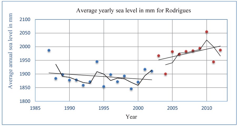
Average yearly sea level for the period (1987 to 2012) along with the trend line and the 2-year moving average for Rodrigues. The data series are divided into the period when sea level is decreasing (blue) and when it is increasing (red). (TNC, 2016)
Sea level rise has been observed to be accelerating in the last decade at an average rate of 5.6 mm/yr compared to the global value of 3.2 mm/yr.