Mauritius' geographical location makes it vulnerable to cyclones, but advances in meteorology, building practices, and disaster management have significantly mitigated the risks associated with such natural disasters. The country continues to enhance its resilience and preparedness to handle the impacts of tropical cyclones effectively.

What is a tropical cyclone? | Meaning of common terms used | |
A warm-core non-frontal synoptic-scale cyclone, originating over tropical or subtropical waters, with organized deep convection and a closed surface wind circulation about a well-defined centre. Once formed, a tropical cyclone is maintained by the extraction of heat energy from the ocean at high temperature and heat export at the low temperatures of the upper troposphere. In this they differ from extratropical cyclones, which derive their energy from horizontal temperature contrasts in the atmosphere. | Centre of the tropical disturbance: Geometric centre of the cloud eye or, if not discernible, the wind/pressure centre. Eye of the tropical disturbance: Relatively clear and calm area inside the circular wall of the convective clouds, the geometric centre of which is the centre of the tropical disturbance. Direction of movement of the tropical disturbance: Direction towards which the tropical disturbance centre is moving. Speed of movement of the tropical disturbance: Speed of movement of the centre of the tropical disturbance. Gust: Instantaneous peak value of surface wind speed recorded or expected | |
Naming of tropical storms in the South West Indian Ocean Basin | ||
The system of naming tropical cyclones was introduced in 1960, which will be remembered as the year during which Mauritius was struck by cyclone “Alix” and by cyclone “Carol”, the most devastating cyclone on record. Madagascar, Reunion, Seychelles, Comores, and Mauritius use a common list of names for identifying tropical storms. Mauritius is responsible for naming storms forming in the region lying between longitude 55ºE and 90ºE. Madagascar is responsible for the region west of longitude 55ºE and the Australian Bureau of Meteorology for the region east of 90ºE. Whenever a cyclone moves from the Australian region of responsibility to that of Mauritius, it keeps its Australian name as per decision of the Tropical Cyclone Committee held in Nairobi in 2010. | ||
Season and Lifecycle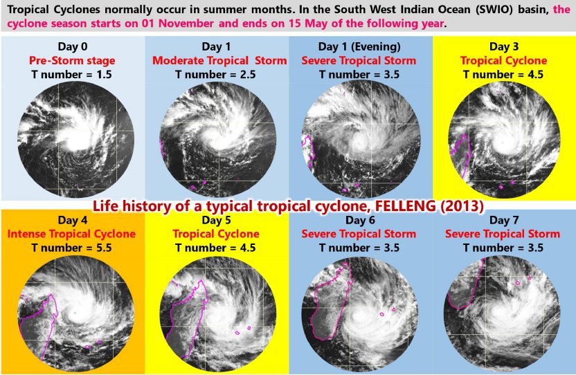  |  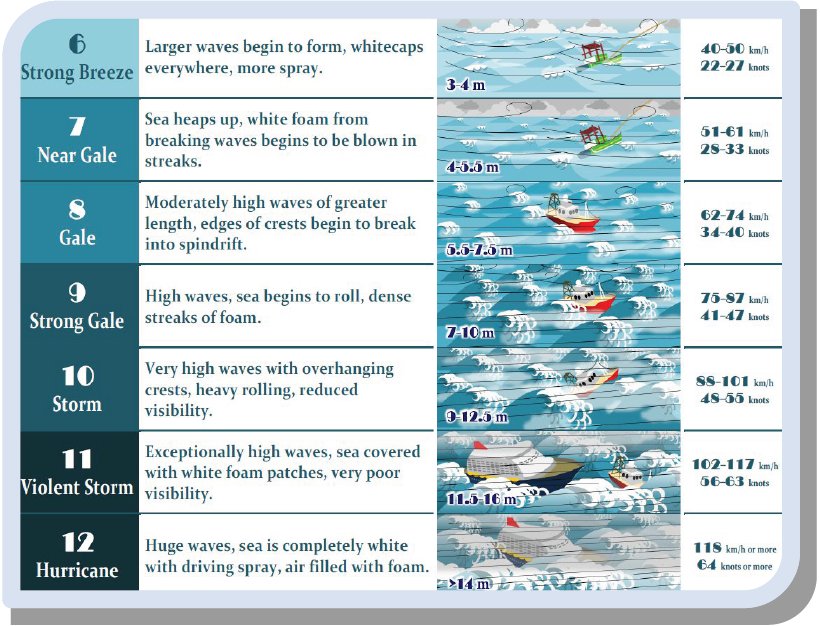 | |
Occurrence | ||
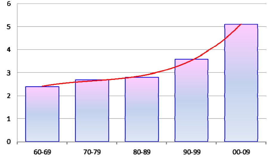
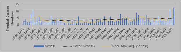
Approximately 10% of the world's tropical cyclones originate in the Southwest Indian Ocean near Mauritius. The figure presents the average annual occurrence of tropical cyclones in this region. Situated at the tail end of the Indian Ocean cyclone belt, Mauritius has typically faced fewer cyclones historically. From 1960 to 1969, the average was 2.4 cyclones per year. However, this average increased to 5.1 cyclones per year from 2000 to 2009, demonstrating that the frequency of tropical cyclones nearly doubled over the span of four decades. Nonetheless, a 2020 US study highlighted a significant shift, showing an 18% increase per decade in the likelihood of major tropical cyclones in the region- see Figure Although many cyclones do not make direct landfall, the islands frequently experience the effects of large storms, resulting in annual flooding in low-lying areas and extensive damage to infrastructure, buildings, crops, and livestock. Additionally, the average frequency of intense cyclones—with wind gusts surpassing 165 km/h—increased from 3.9 between 1981 and 2020 to 4.7 between 1991 and 2020. Current forecasts also predict a future increase in cyclone intensity occurring over shorter durations. |
Movement of Tropical Cyclone Occurrence Average in Southwest Indian Ocean every 10 years | |
 | ||
Notable Tropical Cyclones Affecting Mauritius | ||
|  List of Tropical storms/cyclones when warnings were issued for Island of Mauritius since 1991 | |
Impacts | ||
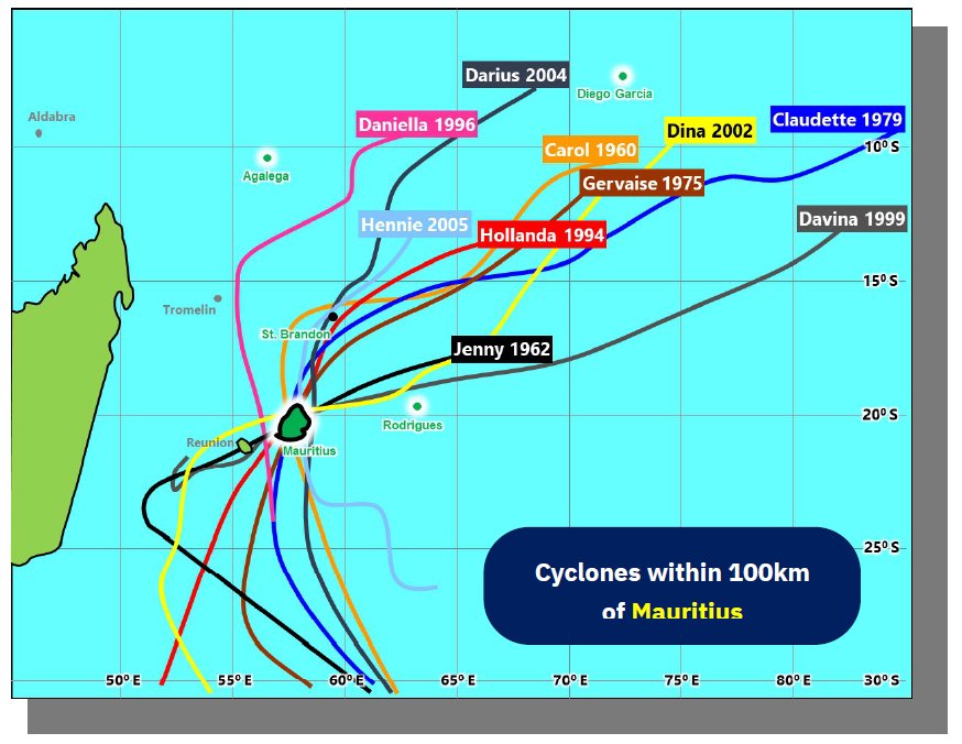
When a cyclone strikes, it can inflict widespread damage on a nation, leading to significant numbers of victims and extensive economic losses. In Mauritius, where the population is densely concentrated and economic activities are robust, the severe damage caused by tropical cyclones is a critical factor in major setbacks to social and economic development. .jpg) The accompanying table lists the damages caused by natural disasters in Mauritius from 1960 to 2009, highlighting the tropical cyclones shown in the figure (tracks of the most severe cyclones that affected Mauritius) marked in red. Cyclone Fantala in 2016, which led to evacuations on Agalega’s South Island, highlight these ongoing challenges. More recently, Cyclones Berguitta and Gelena in 2019 caused extensive damage, power outages, and forced many people from their homes. Mauritius is expected to face about $91 million in direct annual losses due to winds, flooding, and storm surges from tropical cyclones. Half of these losses typically affect the residential sector, while nearly 30% impact the commercial sector. The costs related to emergency responses to tropical cyclones are estimated to average nearly $21 million annually. Over a 100-year period, the projected losses for Mauritius from tropical cyclones could reach $1.9 billion. Rodrigues Island is predicted to experience even more severe effects, with potential 100-year storm winds surpassing 200 km/h, compared to the current maximum of 165 km/h. Flooding in Mauritius, exacerbated by tropical cyclones, is also expected to worsen under these projections (RoM 2021). | 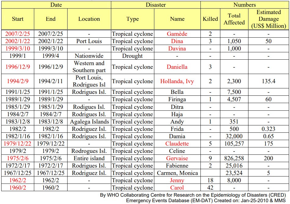 | |
Projections | ||
Projections indicate that:
| 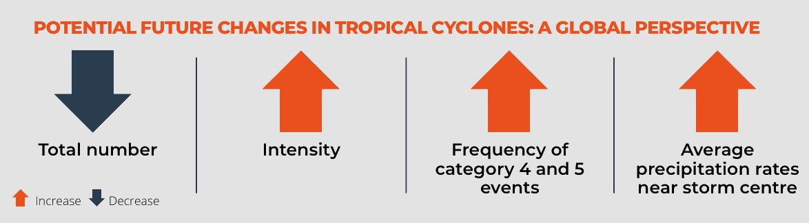 | |
Cyclone Preparedness | ||
Infrastructure and Building Codes: Over the years, building codes have been strengthened to withstand cyclonic conditions, which has helped reduce the damage from more recent cyclones. | 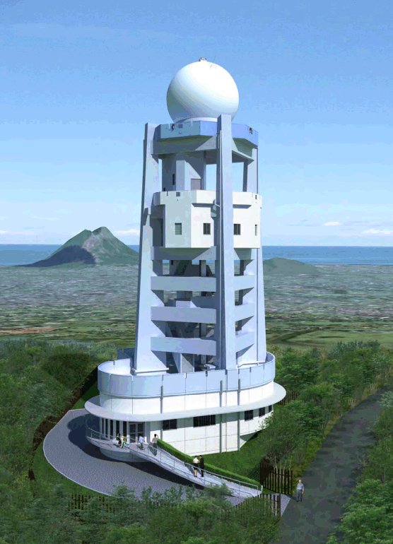 RADAR installed at Trou aux Cerfs, Curepipe | |
Useful Links (MMS) | ||