
Mauritius, Rodrigues and the other outer islands are all located in the Indian Ocean, where the risk of tsunamis, although relatively low, exists primarily due to seismic activities in distant locations.
Is Mauritius At Risk?
The most catastrophic tsunamis typically arise from large, shallow earthquakes with epicenters or fault lines near or on the ocean floor, particularly in areas characterized by tectonic subduction at plate boundaries. It is important to note that not all earthquakes lead to tsunamis; generally, an earthquake must reach at least a magnitude of 7.5 on the Richter Scale to generate a destructive tsunami, according to the International Tsunami Information Centre.
The SWIO region, lacking any known subduction zones, does not typically experience high-magnitude subduction-zone earthquakes. However, this area could still be at risk from tsunamis initiated by subduction zones elsewhere in the Indian Ocean, as noted by the World Bank Group and GFDRR in 2016.
Tsunamis can have varying impacts on coastal areas, depending on several key geographical factors. Understanding these influences is crucial for assessing risk and enhancing preparedness.
Mauritius and its outer islands have fortunately experienced only minor effects from tsunamis, demonstrating favorable geographical protections.
December 26, 2004 Tsunami: During this significant event, Mauritius experienced minimal tsunami-related inundation, highlighting the island's protective geographic features. In contrast, Rodrigues, with possibly different coastal and underwater topographies, encountered a slightly greater impact.
While historical data shows that Mauritius and Rodrigues have not suffered significant damages from tsunamis, it remains imperative to maintain robust disaster preparedness systems. Ensuring that early warning systems and evacuation plans are well-established will safeguard these communities against potential future tsunamis, regardless of their past experiences.
What Is A Tsunami?
A tsunami is a series of waves traveling at speeds of over 800 km/h in the deep ocean where they go unnoticed. Once the waves reach the shallow waters of the coast, the energy of the huge water body manifest themselves as they crash with devastating force across the shore and penetrates inland, particularly low-lying areas, causing mass devastation in terms of lives and property on its way.. Tsunamis are generated primarily by earthquakes occurring on the ocean floor. Underwater volcanic eruptions, landslides or a meteorite can also generate tsunamis.
What Type Of Earthquake Generates A Tsunami?
Tsunamis are typically generated by earthquakes that occur along subduction zones. A subduction zone is an area on the earth where two tectonic plates meet and move towards one another, with one sliding underneath the other and moving down into the earth at rates typically measured in centimetres per year.
Key Factors Influencing Tsunami Impacts
Onshore Topography: The physical features of the land immediately adjacent to the coast can significantly affect how a tsunami wave behaves as it reaches shore. Higher elevation or steep landforms can act as natural barriers, reducing the extent of inundation.
Offshore Topography (Bathymetry): The contour and features of the sea floor near the coast play a critical role in modulating tsunami waves. Variations in sea depth can amplify or diminish the wave intensity as it approaches the land.
Directivity of Maximum Energy Waves: The direction from which the maximum energy of the tsunami emanates determines the impact's focus. Coastal regions directly facing the energy path are more likely to experience severe effects.
Potential sources of Tsunami in the Indian Ocean
Extensive studies and assessments on potential tsunami sources, focusing on their occurrences, seismic activity, and convergence rates, have identified only the subduction and compression zones as likely origins of tsunamigenic earthquakes in the Indian Ocean.
Notable zones include the Sunda Arc, Makran Subduction Zone, Davie Ridge, and the Central Indian Ridge, as detailed in studies by Jaiswal et al., Okal et al. (2008), and Satake (2014).
Regions C and D, which exhibit primarily horizontal plate movement and lack any recorded earthquakes of magnitude 7.5 or higher, are considered to have minimal tsunami risk since their geological activity does not result in significant vertical displacement of the ocean floor.
In response to public concern over earthquake and tsunami risks, the Mauritian Government commissioned a study in 2012 entitled 'Risks of Earthquakes and Tsunami for Mauritius and Rodrigues'. Led by Prof. Dr Montagner, the study highlighted that earthquakes on the Mid-Oceanic ridge typically occur along normal and transform faults with relatively low magnitudes compared to those in subduction zones, and the likelihood of a magnitude 7.0 earthquake is very low. Only vertical movements along normal faults might generate a tsunami. Additionally, gravitational collapses of the slopes of the volcano Piton de la Fournaise could potentially trigger a tsunami affecting Mauritius, though the displaced masses are likely too small to cause significant regional impacts.
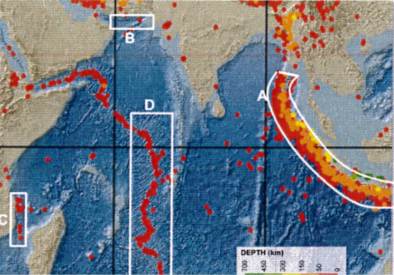
Potential sources of tsunami in the Indian Ocean. A, Sunda Arc; B, Makran Subduction Zone; C, Davie Ridge; and D, Central-Indian Ridge (World Bank Group, GFDRR, 2016).
Notable Events
The 9.0-magnitude undersea megathrust earthquake of December 2004 near Sumatra, Indonesia, which triggered the Indian Ocean tsunami, is estimated to have killed at least 80,000 people, with more than 200,000 estimated to have died from the resulting tsunami and coastal run-up.
Although Mauritius did not experience any direct hits or significant damage from the waves, the event significantly heightened awareness and led to the development of better preparedness strategies within the region.
Tsunami Risk Assessment and Preparedness in Mauritius
The 2004 tsunami resulted in significant destruction and loss of life across the Indian Ocean region, impacting distant locations like South Africa. Mauritius, shielded in part by coral reefs which dampened the tsunami's force, experienced only minor flooding, though Rodrigues faced more substantial effects.
The geographic orientation and bathymetry around Mauritius provide some natural protection against tsunamis, but the risk cannot be entirely ruled out, especially from high-magnitude earthquakes in distant parts of the Indian Ocean.
Continuous efforts in monitoring, public education, and evacuation planning are essential components of the national strategy to mitigate the impact of potential tsunamis.
In case of a tsunamigenic earthquake has occurred, the 3 Tsunami Service Providers (TSP) namely India, Indonesia and Australia issue earthquake information bulletins and advisories' & ' Indian Ocean-Wide Tsunami Wave Exercise.
Regular public awareness campaigns and drills are conducted to educate the population about the tsunami threat and the appropriate response actions to take in case of an emergency.
The primary motive for IOWave exercise is also to enhance tsunami preparedness at community level. Other benefits include strengthening coordination throughout the region and evaluate response capabilities of our country. NDRRMC, Local Authorities, public and private organisations including hotels and schools participated in the Regional Exercise which was carried out in 2014, 2016, 2018, 2020 and 2023.
Tsunami Warning System (TWS)
Following the devastating Sumatra Earthquake and the subsequent Indian Ocean Tsunami on December 26, 2004, nations within the Indian Ocean region established the Intergovernmental Coordination Group (ICG). This body was tasked with developing the Indian Ocean Tsunami Warning System (IOTWS), which facilitates the sharing of seismic and sea-level data essential for the swift detection and analysis of tsunamis. The system aims to provide timely warnings and coordinate mitigation efforts across member states, ensuring a proactive response to tsunami threats 24/7, thereby safeguarding coastal communities by prompting them to undertake lifesaving actions promptly.
The IOTWS operates as a composite entity where each National Tsunami Warning Centre (NTWC) of the 28 member states issues localized tsunami warnings based on threat assessments relayed by three Tsunami Service Providers (TSPs) located in Australia, India, and Indonesia. These centers also disseminate regular updates regarding wave progression, expected times of impact, and wave heights at beaches to help at-risk nations maintain heightened alertness and implement necessary safety measures. The Mauritius Meteorological Services acts as the NTWC for the Republic of Mauritius. The Mauritius Meteorological Services is designated as the National Tsunami Warning Centre for the Republic of Mauritius. It is responsible for Earthquake and Tsunami monitoring and issuance of warning. Apart from an MRIV (seismometer) station at Vacoas, monitoring is done through USGS and CISN websites.
TWS Stages
As at now occurrence of a Tsunami cannot be predicted and paradoxically it can occur at any time during a year and at any time during a day. The Tsunami Warning System in Mauritius has taken into consideration the degree of risk as well as the time factor. In virtue of its geographical location, Mauritius and Rodrigues have a lead-time of 5-7 hours before tsunami waves are likely to reach their coasts from either the Sumatra or the Makran source.
The warning system in Mauritius consists of three stages:
- Tsunami Watch: Issued when a strong earthquake (magnitude > 7.0) occurs near the Indian Ocean, signaling a potential tsunami; advises the public, especially sea-goers and fishermen, to avoid the sea and secure boats ashore.
- Tsunami Warning: Confirms an imminent tsunami set to impact Mauritius/Rodrigues within 5-7 hours, necessitating immediate evacuation of vulnerable coastal areas based on proximity and urgency.
- Termination: Announced after confirming with police, fisheries, environmental officials, and tide gauge observations that there is no longer a threat of significant tsunami waves.
Tsunami inundation maps
Tsunami inundation maps are crucial tools for disaster preparedness and risk reduction. They are indispensable in enhancing tsunami preparedness and resilience, significantly contributing to the reduction of loss of life and property damage during such catastrophic events:
- Emergency Planning and Response: Inundation maps help authorities plan evacuation routes and emergency response strategies by clearly delineating areas likely to be affected by tsunami waters. This information is vital for developing effective emergency response plans that can be activated swiftly in the event of a tsunami.
- Public Awareness and Education: These maps serve an educational purpose, increasing public awareness about the areas at risk of tsunamis. They help communities understand their vulnerability and the importance of evacuation plans, which is essential for enhancing public safety.
- Infrastructure and Development Planning: Inundation maps inform planners and developers about high-risk zones, guiding the location and design of infrastructure to minimize potential damage. This includes the strategic placement of hospitals, schools, utilities, and other critical facilities outside high-risk areas.
- Risk Assessment: They provide a basis for detailed risk assessments, allowing for the analysis of potential impacts on populations, properties, and economic activities, which is essential for insurance purposes and investment decisions.
- Mitigation Strategies: By identifying the most vulnerable areas, tsunami inundation maps enable governments and communities to implement targeted mitigation strategies, such as constructing sea walls, breakwaters, and other coastal defenses to reduce the impact of tsunami waves.
- Research and Simulation: These maps are used by researchers to simulate tsunami scenarios and improve understanding of how tsunamis interact with coastal geographies. This ongoing research helps to refine future maps and improve accuracy in predictions and warnings.
Tsunami Inundation Maps were produced for Mauritius and Rodrigues as far back as 2006 by a team of researchers at MOI and University of Mauritius based on 1:100,000 maps. At the request of the National Disaster Risk Reduction Management Centre (NDRRMC), MOI has generated the
latest version of inundation maps for Mauritius and Rodrigues based on numerical modelling for the 2004 Sumatra tsunami event (Makran Trench scenario) at scale of 1: 75,000 and using bathymetric data. Simulations for the other outer islands of the Republic of Mauritius can only be carried out after acquisition of high resolution bathymetric and elevation data.The bathymetry and topographical details are important in identifying the evacuations in case of an impact of tsunamigenic earthquake.
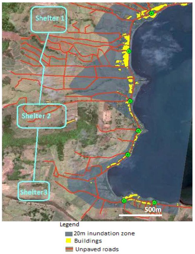
Proposed Shelter Locations (source: Mudhawo and Suresh, 2020)