
While Mauritius and its territories are not prone to frequent or severe earthquakes, the possibility of minor seismic events or indirect impacts from distant earthquakes, like tsunamis, is acknowledged in disaster preparedness and response strategies.
Earthquakes are relatively common in the Southwest Indian Ocean region; however, the primary seismic sources, the Mid-Indian Ridge in the Indian Ocean and the East-African Rift system, are located far from Mauritius. The seismic activity in these areas tends to be frequent but generally of low to moderate intensity. As a result, Mauritius has not experienced significant economic losses or casualties due to earthquakes. Losses from significant seismic events are considered rare, with direct damages not anticipated for earthquakes having a 500-year return period. The average annual losses from earthquakes in Mauritius are primarily associated with extremely infrequent earthquakes that have return periods exceeding 500 years. The Mauritius Meteorological Services is designated as the National Tsunami Warning Centre for the Republic of Mauritius. It is responsible for Earthquake and Tsunami monitoring and issuance of warning. Apart from an MRIV (seismometer) station at Vacoas, monitoring is done through USGS and CISN websites. Mauritius and its outer islands, including Rodrigues, Agalega, and the Cargados Carajos Shoals, are generally considered to have low seismic activity. The region does not lie on any major tectonic plate boundaries where most of the world’s significant earthquakes occur. Although Mauritius has a limited risk of seismic activity, it remains vulnerable to tsunamis triggered by deep-sea earthquakes originating from either Sumatra or Makran. For instance, a wave runup of 2.9 meters was recorded on Rodrigues Island as a consequence of the December 2004 Indian Ocean tsunami. | What is an Earthquake?An earthquake (also known as a quake, tremor or temblor) is the shaking of the surface of the Earth resulting from a sudden release of energy in the Earth Lithosphere that creates seismic waves.  | |
Historical Seismic Activity in MauritiusHistorically, Mauritius has experienced only minor seismic activity. These events are infrequent and typically of low magnitude, insufficient to cause significant damage. Felt on Mauritius Between 1786 and 1925: Bureau de recherches géologiques et minière (BRGM) document five seismic events between 1786 and 1925 (exact locations remain unknown due to the absence of seismometers in the region at that time. ) Recent seismic events (no tsunami):
Tsunami Threats While direct seismic threats are low, Mauritius could be affected by tsunamis generated by distant earthquakes. For example, the 26 December 2004 Indian Ocean earthquake and tsunami, which primarily impacted coastal areas around the Indian Ocean, led to increased awareness and preparedness initiatives in island nations like Mauritius. | 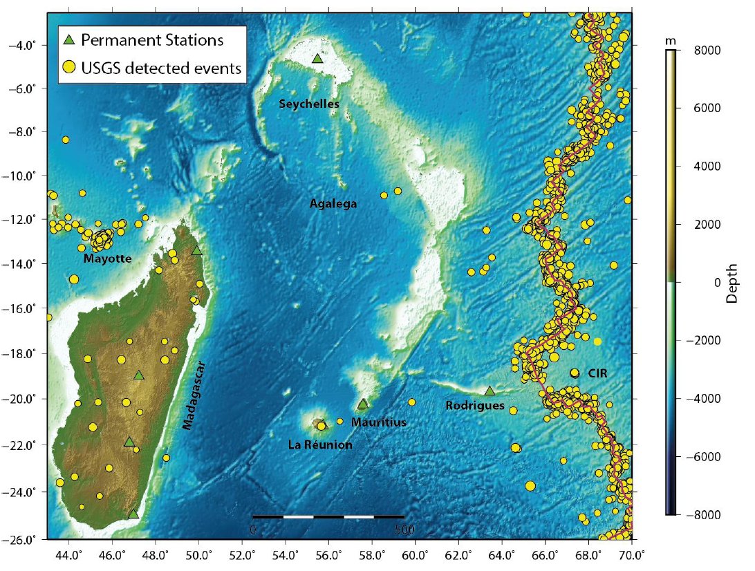 Green Triangles: Permanent stations from various global networks Red solid line: Central Indian Ridge Yellow Circles: Earthquake locations from USGS catalogue (1900-2019) source: MOI | |
Preparedness and MonitoringThe Mauritius Meteorological Services monitors seismic activity and provides alerts and updates on significant global seismic events that could potentially generate tsunamis affecting the region. Though the direct threat from earthquakes is low, the government has implemented measures to improve disaster preparedness, including tsunami readiness, especially after the 2004 Indian Ocean tsunami. |  |