Mauritius and its outer islands are susceptible to flood and drainage problems, primarily due to heavy rainfall events, especially during the cyclone season from November to May. The topography of the island, with central highlands and rapid runoff towards coastal plains, exacerbates the risk of flooding, particularly in urban areas like Port Louis where rapid development and inadequate drainage can lead to significant water accumulation.
Flooding Events
The increasing frequency and severity of flood events, driven by climate change, are particularly challenging for Mauritius (and other Small Island Developing States), compromising their resilience and recovery capabilities in the face of extreme weather events.
Notable Flooding Events in Mauritius
2008: Heavy rains in March caused significant flooding across the island, particularly affecting the capital, Port Louis, and resulting in considerable property damage and disruption of daily activities.
30 March 2013: One of the most severe flooding events occurred in March, when a sudden, extreme rainfall event led to flash floods in Port Louis. The floods resulted in the deaths of 11 people and extensive damage to infrastructure and private properties. This event highlighted the vulnerability of urban drainage systems to intense rainfall and led to significant changes in flood management strategies.
2015: Mauritius experienced another major flooding event in March, particularly impacting the northern and central regions of the island. The government continued to work on improving flood resilience, focusing on drainage infrastructure.
2016: Cyclone Carlos in February caused widespread flooding, again bringing to light the ongoing challenges of managing heavy rainfall during cyclone events.
2018 and 2019: Both years saw localized flooding during the cyclone season, prompting further enhancements in emergency preparedness and response mechanisms.
15 January 2024: Cyclone Belal caused substantial flash floods and widespread flooding, severely affecting Port Louis and other regions. The floods resulted in the deaths of 2 people and extensive damage to infrastructure and private properties. The cyclone led to submerged vehicles, and extensive damage to infrastructure.
21 April 2024: 100+mm rainfall caused flooding events on affecting regions in the West, Southwest, and even the Northwest, including areas like Bambous, Geoffroy, Grande-Rivière Nord-Ouest, and Port-Louis.
DID YOU KNOW:
Floods are common global phenomena that have substantial socio-economic consequences, including loss of life and property damage.
Flash floods occur rapidly, often within hours of excessive rainfall, causing swift rising of water levels. Regular floods, however, develop more gradually, typically from prolonged rain, and may last longer, affecting broader areas.
Land Drainage Master Plan (LDMP) - 2022
A Climate-Resilience Strategy
Developed by the Land Drainage Authority (LDA) with technical and financial support from the Agence Française de Développement (AFD), the LDMP was launched in 2022 with an estimated budget of Rs 70 million.
On 25 Aug 2025 were officially unveiled:
- the Land Drainage Master Plan (LDMP), outlining a comprehensive national strategy to mitigate flood risks and strengthen resilience to climate change and
- the Digital Elevation Model (DEM)—a detailed land map identifying flood-prone areas and guiding safe development—was also released.
The LDMP provides a long-term, integrated framework that combines engineered solutions, nature-based measures, and zoning regulations to improve the management of the country’s drainage systems.
An independent Technical Committee ensured alignment with international frameworks such as the SDGs, the Sendai Framework, and the Paris Agreement. The LDMP was reviewed in detail, including feasibility studies, flood-risk mapping, social and environmental safeguards, and institutional capacity.
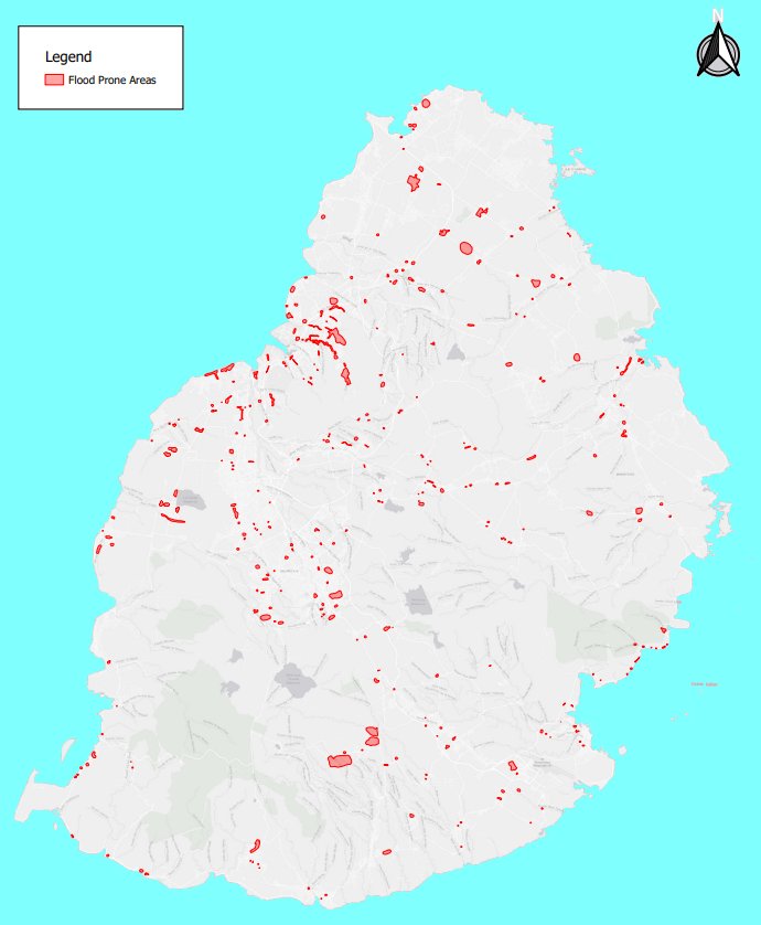
Identified High-Risk Zones
The LDMP identified 16 flood-prone sites across Mauritius:
Nouvelle France
Bel Ombre
Grand Baie–Pereybere
Flic en Flac
Several regions of Port Louis (Rivière-du-Pouce, La Poudrière, Ruisseau des Créoles, La Paix, Canal Anglais, Canal Dayot, Rivière Lataniers)
Henrietta–Malakoff
Pointe aux Sables
Roche Bois
Coteau Raffin
Clémencia–Pont Lardier
Mapou, Piton, Cottage
Flacq
Vacoas
Quatre Bornes
Camp Caval–Curepipe
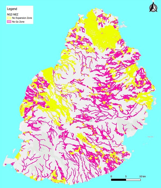
These areas are categorised into:
No-Go Zones – where construction is strictly prohibited unless specific upstream works are undertaken, covering 11% of Mauritius’s land area (218.33 km²).
No-Expansion Zones – where only vertical construction may be authorised, representing 4.5% (94.01 km²).
Together, flood-prone areas represent 15.5% of the country’s total land area.
Key Recommendations and Measures
The LDMP is not only a technical document but also a policy instrument for climate resilience. The Technical Committee put forward several priority measures:
Emergency Preparedness – development of evacuation and safety protocols for the 16 high-risk sites in coordination with the National Disaster Risk Reduction and Management Centre (NDRRMC), the Mauritius Fire and Rescue Service, and local authorities.
Fast-Tracking Infrastructure – creation of a dedicated LDA implementation unit to accelerate priority drainage works in vulnerable sites.
Improved Mapping and Land Management – upgrading flood-risk mapping, implementing fast-track land acquisition with fair compensation, and aligning land development approvals with LDMP zoning.
Institutional Strengthening – reinforcement of the LDA with specialised teams for land acquisition, monitoring, and enforcement, supported by possible international cooperation.
Nature-Based and Sustainable Drainage – guidelines to reduce soil impermeability, encourage rainwater infiltration, and integrate Nature-Based Solutions (NBS) into urban planning.
From 1 October 2025, new enforcement measures will take effect: property owners who allow rooftop water to flow onto roads or pavements due to inadequate drainage will be subject to a fixed penalty fine between Rs 2,000 and Rs 10,000.
A national flood response and evacuation plan will soon be finalised with the National Crisis Committee to ensure preparedness before the rainy season.
The susceptibility of Mauritius to flooding is a significant concern that requires ongoing attention to infrastructure, urban planning, and community preparedness to mitigate the impacts effectively. The combination of natural geographic features and climatic conditions makes robust flood management an essential aspect of the island's disaster risk reduction strategy.
Drainage Infrastructure Upgrades: Following the 2013 floods, the Mauritian government has invested in upgrading and expanding urban drainage systems to handle higher volumes of stormwater.
Flood Mapping and Risk Assessment: Authorities have developed more detailed flood maps and risk assessments to better understand and mitigate flood risks, particularly in highly vulnerable areas.
Community Engagement and Awareness: Regular public awareness campaigns are conducted to educate residents about flood risks and appropriate response measures during heavy rainfall events.
Emergency Response Planning: The improvement of emergency response strategies, including the pre-positioning of resources and the establishment of clear evacuation routes and shelters, has been a priority.
Green Infrastructure: Efforts have been made to implement green infrastructure solutions, such as rain gardens and permeable pavements, to increase natural absorption of rainwater and reduce surface runoff.
At the level of the NDRRMC, three major actions (soft measures) have been undertaken with regard to the 56 life threatening/critical sites, as follows: * Implementing Community Disaster Response Programme (CDRP); * Sensitisation Campaigns; and * Development of Emergency / Contingency Plans.
Moreover, the NDRRMC is also assisting the local authorities to prepare the respective emergency / contingency plans for these 40 regions. During the CDRP, the community is also sensitised on basic precautionary measures, amongst others.