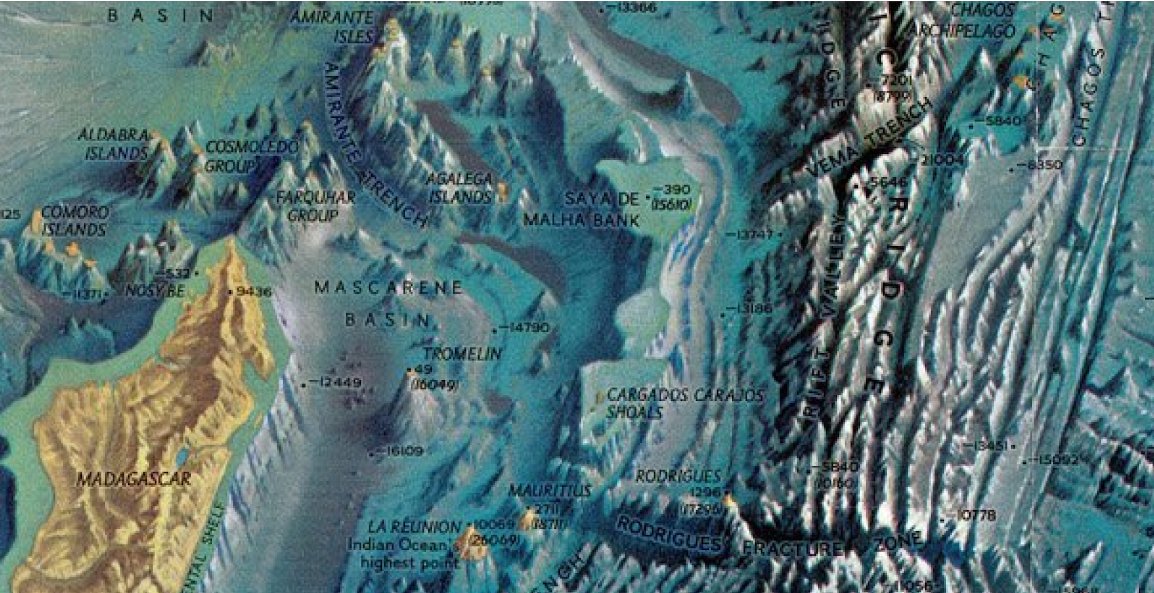
Bathymetry of the EEZ of MauritiusMauritius, located in the southwestern Indian Ocean, has a unique maritime environment that includes shallow coastal waters, deep ocean basins, and underwater features. The coastal regions of the Republic of Mauritius are generally characterized by relatively shallow waters, especially along the coastlines of the main island, Rodrigues, and other smaller islands. These shallow areas are vital for various activities, including fishing, tourism, and recreational water sports. Mauritius features extensive submarine plateaus, such as the Mascarene Plateau, which extends across a substantial portion of its EEZ. These plateaus are known for their shallower depths and support diverse marine life. Beyond the submarine plateaus, the EEZ of Mauritius descends into deep ocean basins with considerable depths. These areas provide habitats for various pelagic species and are essential for fisheries and oceanographic research. The EEZ of Mauritius includes numerous seamounts, underwater mountains, and other geological features. These seamounts often attract marine life, making them important locations for fisheries and biodiversity. The region also encompasses rift valleys and associated geological formations. These valleys can be relatively deep and have unique ecological characteristics. Mauritius has conducted extensive bathymetric surveys and research to better understand its underwater topography. These efforts are essential for fisheries management, conservation, and scientific exploration. The Chagos Archipelago lies to the northeast of Mauritius. The bathymetry in this region includes a complex network of atolls, channels, and deeper oceanic areas. The diverse bathymetry of the EEZ supports a wide range of marine species and ecosystems, including coral reefs, deep-sea habitats, and pelagic fish populations. It is crucial for maintaining the ecological balance and the sustainability of fisheries. Understanding the bathymetry of the EEZ of Mauritius is essential for effective marine resource management, conservation, and the sustainable development of the Blue Economy. |
source: Baseline study. Indiand Ocean Expedition. Sept 2022. https://www.monacoexplorations.org/ |
Ocean Temperature: SST & Vertical Temperature ProfileThe ocean temperature in the Mauritius region aligns with tropical norms, lacking significant upwelling areas. The warmest period occurs in early March, reaching around 29°C, while the coldest phase starts in September with an average sea surface temperature of 23°C. Summer months may witness temperatures peaking at 31°C, leading to fish mortality and coral bleaching. The annual temperature range spans 6°C, with a relatively small diurnal range in the open sea but potentially reaching 3°C in lagoons during calm summer days. A 50m-thick isothermal layer exists, and below the mixed layer, a thermocline is present, characterized by a rapid temperature decline with depth. Typically situated around 100m below the ocean's surface, the thermocline deepens during winter months. The challenges associated with ocean temperature encompass:
|
source: MOI |
SLR, Tides & WavesBased on tide gauge station data, Emery and Aubrey (1989) calculated a relative sea-level rise of approximately 3 mm/year. Another study suggested a rise of about 1.2 mm/year since 1965, comparable to global sea level changes over the last century (Ragoonaden 1997). Data analysis from 1986 to 2003 showed minimal sea level changes (Ragoonaden 2006a, 2006b). However, recent data from the University of Hawaii Sea Level Centre indicates an acceleration in sea level rise over the past five years, as illustrated in Figures 8 and 9. Additionally, a new sea level station has been installed at Agalega as part of the Tsunami Monitoring Network. The tidal patterns along the coast of Mauritius mirror those of a natural open-ocean setting due to the island's limited continental shelf width. The tides exhibit a semi-diurnal nature, with a tidal range of approximately 0.50 m during spring tides and a smaller amplitude of about 0.20 m during neap tides. Notably, during annual spring tides in March and September, the tidal range can reach up to 0.85 m. In exceptional cases, very low water levels may occur, causing the water to drop more than 1 m below mean sea level. The wave climate in Mauritius is mainly influenced by three primary weather systems:
Cyclonic induced waves: Tropical cyclones, forming in the southwest Indian Ocean between November and May, typically approach Mauritius from the northeast. These cyclones generate very high waves, with peak significant wave heights exceeding 15 m. The intensity, duration, and path of the cyclone play a role in determining the wave characteristics that reach Mauritius. Wave data from ship observations remain a major source, indicating that the average height for local wind waves is less than one meter, while swell averages close to two meters. The more extreme wave heights can reach up to 3.5 m for sea waves and 5.4 m for swell. Over 80% of all waves approach from the ENE to SSE sectors, with waves from the NW occurring less than 2% of the time. Southerly swells from the S to SW, exceeding 3 m, occur around 14% of the time. | 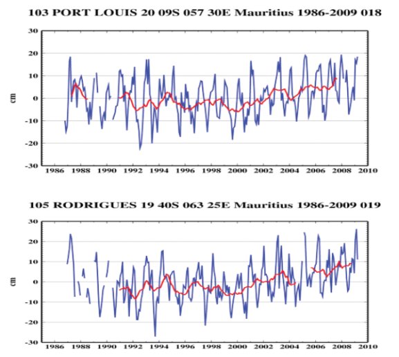 |
Coastal hydrodynamics and offshore current systemsMauritius is situated in a region predominantly influenced by the persistent South Equatorial Current (SEC), driven by the prevailing trade winds from east to west in the south Indian Ocean. This current, extending from 8 °S to approximately 15-20 °E, exhibits notable seasonal variations in strength. Its intensity peaks during the winter months when robust South Easterly trades dominate the south Indian Ocean. Accelerating as it passes through channels within the Mascarene Plateau, the current creates strong gyres on the leeward side. Upon reaching Madagascar, a portion of the current flows northward to join the Agulhas current in the Mozambique Channel and the East African current. The southern segment flows southward along the Madagascan coast, forming an anticyclone gyre further south. During the South West monsoon, the northward-turning component of the SEC contributes to the Somali current along the East Coast of Africa. Coastal hydrodynamics around Mauritius are additionally shaped by factors such as lagoon bathymetry, the presence of coral reefs, shoreline morphology, tidal patterns, and extreme events like cyclones and storm surges. Notably, waves breaking at an angle to the shoreline generate long shore currents, transporting sediments along the coast in most regions. | 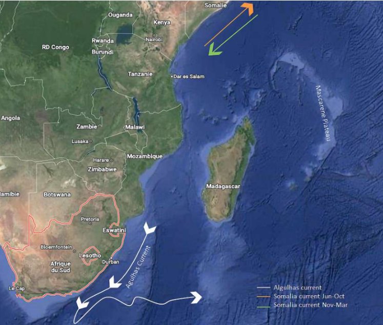 |