
VIEW MAPS: (Google Map; Ministry of Housing & Lands) |
Agaléga - A Coral Atoll North of Mauritius | ||
Discovery and Early HistoryAgaléga was officially discovered by the Portuguese shortly after Vasco de Gama's journey in 1498, which allowed access to the Indian peninsula's wealth. The island was named "Ilha Gallega" by Juan de Nova, a navigator of Galician origin, in 1501 to honor his homeland. The island had few attractions for its early visitor and overlooked for over two centuries. In 1758, during an expedition by Governor Mahé de La Bourdonnais, Agaléga was annexed to the French possessions in the Indian Ocean. The island was administratively part of the Isle de France for half a century. In 1814, alongside the Isle de France, Agaléga was transferred to the United Kingdom and subsequently ceded to Mauritius after the end of British colonization. Agaléga is managed by a company of the State of Mauritius, the Outer Island Development Company (OIDC). The company delegates a resident manager, a kind of steward, who is the supreme authority on the two islets. Despite its modest size and limited land for development, Agaléga is considered one of Mauritius's principal dependencies, mainly due to its fishing rights and potential underwater resources, which are significant to its economic value. The economy of the archipelago is based primarily on the exportation of coconut oil.
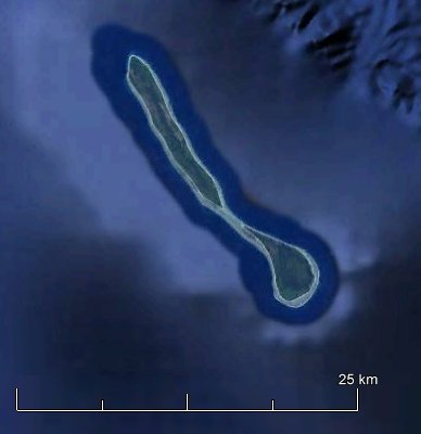
Geographic Description
Geomorphological Features
Climate(Data sources: Government of Mauritius 2005, Mauritius Meteorological Services 2010) Agaléga experiences a hot, torrid, and humid tropical climate. Temperature: There is minimal seasonal variation in temperature.
Rainfall: Agaléga receives rainfall year-round despite its low elevation.
Population and Economy
Biodiversity
|     | |
Looking Ahead
A number of efforts mark just the beginning of a strategic vision aimed at fostering a resilient, prosperous future for all Agalegans. The Government is committed to ensuring that Agaléga not only thrives but also becomes a model of sustainable development and community welfare.
Major Infrastructure Developments:
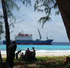
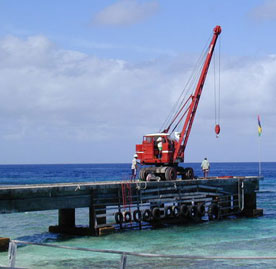
Agaléga is on the brink of a transformative era with the completion of two significant infrastructure projects: a new airstrip and jetty. These developments are set to enhance both air and sea access, significantly improving the quality of life for residents and opening up broader economic opportunities.
Sustainable Development and Environmental Protection:
In addition, the implementation of these projects, ROM's commitment to Agaléga's future encompasses a comprehensive approach to sustainable development and environmental protection. The initiatives include:
- Maritime Security: Surveillance of our expansive Exclusive Economic Zone, spanning 2.2 million square kilometers, alongside measures to combat piracy, terrorism, narcotics, and human trafficking.
- Environmental Stewardship: Efforts to control illegal fishing practices, provide hydrographic services, and respond to marine pollution.
- Economic Initiatives: Promotion of economic development through blue economy initiatives and vital emergency services including search and rescue operations.
- Community Support: Offering humanitarian aid and facilitating disaster relief activities to safeguard and support the Agaléga community.
These projects will go a long way towards improving the air and sea access to the island and contribute significantly to improving the standard of living of our Agalegan brothers and sisters as well as also broaden the scope of economic activities in Agaléga.
The Agaléga Master Plan:
A dedicated committee within the Prime Minister’s Office is shaping the Master Plan for Agaléga's development, focusing o
- implementation of mitigation measures against beach erosion;
- protection of historical monuments;
- provision of sports facilities;
- development of fishing;
- upgrading of health services;
- boosting food crops and livestock production,
- improving fire and rescue service;
- enhancement of educational facilities;
- improvement of land transport facilities,
- improvement of internet and mobile connectivity,
- construction of housing units and maintenance of existing units and staff quarters, and
- employment opportunities and training.