Rodrigues Island, with its unique geographical and environmental characteristics, utilizes its land for various purposes that align with its local economic activities and conservation efforts.
Land Use in Rodrigues
Overview of Land and Coastal Areas in Rodrigues
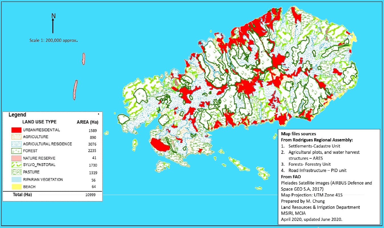
Rodrigues Island covers approximately 10,900 hectares, including its surrounding islets. Around 9% of this land (1,000 hectares) is privately owned, mainly in areas like Port Mathurin, La Ferme, and Saint Gabriel-Mont Lubin. The remainder is state-managed and often leased for residential, agricultural, or commercial development.
State of Land Cover and Vegetation
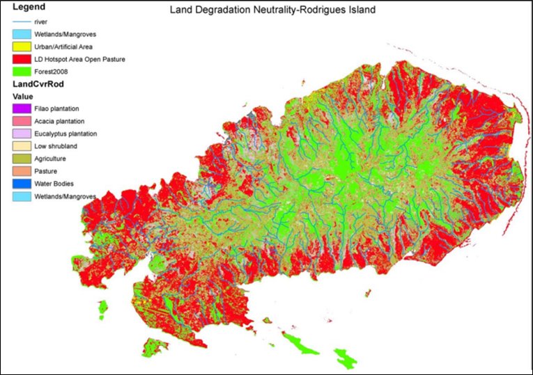
About 30% of Rodrigues' land is covered by planted forests, dominated by invasive species like Acacia nilotica. Native vegetation is limited to restored forest patches, with contiguous native forest areas nearly absent outside of nature reserves. Approximately 30% of the land cover is severely degraded due to subsistence agriculture conversion, exacerbated by intensive livestock rearing and unsustainable agricultural practices on steep slopes.
Land Use in Rodrigues
The evolution of land use in Rodrigues began as a sailors' stopover, rich in natural resources like fresh water and giant tortoises. Colonized by the French in 1691, it saw introductions of various animals. Post-independence in 1968, land use increasingly focused on sustainable management, with significant ecological impacts like deforestation and species extinctions. The establishment of the Rodrigues Regional Assembly in 2001 marked a shift towards formalized land use planning, emphasizing environmental conservation, reforestation, and controlled agricultural practices to promote sustainable development.
Coastal Ecosystem and Management Challenges
The coastline, mainly rocky shores, includes only 16 sandy beaches, many of which are small and impacted by shoreline recession. Human-induced beach erosion is minimal, largely due to limited coastal development. However, specific areas like Port Mathurin have undergone extensive land reclamation and coastal dredging, affecting natural erosion and sedimentation processes.
Environmental Management and Policy Gaps
Several challenges hinder effective management, including inadequately robust policy frameworks, the absence of comprehensive land use policies, and insufficient coordination mechanisms. In Rodrigues, the practice of sand extraction in the lagoon, especially at Banc Catherine, persists despite sustainability concerns. This activity, compounded by the effects of rising sea temperatures and sea levels, risks intensifying erosion and adversely impacting marine ecosystems.
Conservation Efforts and Future Directions
Efforts like placing truck tyres along Ile aux Sables aim to protect against erosion, but more comprehensive environmental assessments and controls are needed to ensure sustainable practices. Rising sea temperatures and sea levels are expected to worsen coastal erosion and impact fisheries, highlighting the need for enhanced conservation strategies and climate resilience planning.
Land Use Type Distribution, 2020 (%)
(Note: Riparian Vegetation: 0.51% and Beach: 0.58%)
Agricultural Land:
Crop Production: The arable land is primarily used for the cultivation of various crops including vegetables, fruits, and spices. Common crops include maize, beans, onions, and garlic.
Livestock Farming: Pastures are allocated for livestock, mainly cattle, goats, and pigs, which are integral to the local diet and economy.
Conservation Areas:
Nature Reserves: Rodrigues has designated areas for conservation to protect its unique biodiversity and endemic species. These areas are crucial for research, conservation, and eco-tourism.
Marine Protected Areas: Parts of the coastal and marine environments are protected to preserve marine biodiversity, including coral reefs and associated ecosystems.
Forest Land:
Woodlands: These areas are primarily composed of mixed forest cover, including both native and introduced species. Forests are used for timber, habitat preservation, and as windbreaks.
Reforestation Projects: Due to past deforestation issues, there are ongoing efforts to restore native forest cover through reforestation projects.
Urban and Built-Up Areas:
Residential: These include housing and associated residential structures spread across various settlements on the island.
Commercial and Services: Areas designated for businesses, shops, and public services crucial for the local economy.
Infrastructure: This includes roads, ports, and the airport, which are essential for connectivity and economic activities.
Barren Land:
Rocky Areas and Cliffs: Parts of the island are covered with rocky outcrops and cliffs, particularly near coastal areas, which are less suitable for agriculture or development.
Recreational Areas:
Beaches and Public Parks: These areas are used for leisure, tourism, and local recreation, contributing significantly to the island’s appeal as a tourist destination.
Water Bodies:
Lagoons and Coastal Waters: The surrounding waters and lagoons are not only key for marine life but also support fishing, which is a vital part of the local economy.
Soils of Rodrigues
The soil dynamics and pedological processes on Rodrigues Island, highlighting the interaction between geological and human influences on soil development are detailed on the right column.
Major Pedological Processes
Current Erosion:
Leads to the formation of raw mineral soils or lithosols and poorly evolved erosion soils.
Creates regosolic soils on soft rocks and lithic soils on hard rocks.
Bisiallitization (Similar to Mauritius):
Involves controlled elimination of silica and bases, forming swelling clays of the montmorillonite family.
Predominant on the external slopes with relatively low rainfall and poor drainage.
Ferrallitization (Similar to Mauritius):
Characterized by leaching of bases and silica, with the release of iron and aluminum hydroxides and formation of kaolinite clays.
Occurs especially in the central region, where conditions are humid and well-draining.
Soil Types and Formation by Region
Coastal and Alluvial Formations:
Includes lithosols and poorly evolved soils on calcarenites and aeolian calcareous sandstones.
Features alluvial and colluvial input soils, with characteristics like deep clayey compositions and frequent ferromanganese concretions in valleys and lowlands.
Colluvial Formations:
Comprises poorly evolved soils of colluvial input and modal tropical eutrophic brown soils.
Soils are variable in depth, clayey, irregularly stony, and sometimes display vertic characteristics on convex slopes.
Rocky Ledges and Scree:
Formed of basalt outcrops associated with poorly evolved erosion soils on volcanic breccias and scoria.
Shield Formations (Hard Rocks):
Encompass semi-desert landscapes with numerous basalt outcrops and prismatic flows.
Includes erosional lithosols and poorly evolved lithic erosional soils, which are shallow and very stony.
Central Sector (Soft Rocks):
Dominated by tuffs and volcanic ash, leading to associations of regosolic and slightly evolved soils.
Features shallow to moderately deep soils, often discontinuous and poorly structured.
Additional Insights
The volcanic phases' uniform age, between 3 and 1.3 million years, contributes to the lack of a clear soil catena, influenced also by low elevation differences.
Deforestation and overgrazing likely exacerbate the prevalence of lithosols, stripping deeper paleosols and affecting soil stability and fertility.
Land and Coastal rehabilitation
Land Use and Development Strategy
Following the Sustainable Integrated Development Plan initiated in 2009, Rodrigues has enhanced land resource management through a robust land-use planning framework, encapsulated in the Rodrigues Land Use Regulations. This framework includes a local plan and a physical development strategy aimed at guiding land use and development over 20 years. Key focuses include clustered development, conservation of natural landscapes, and the development of housing, recreational facilities, and transportation infrastructure.
Ecosystem Management and Conservation
Sustainable Practices: The island is actively developing sustainable landscape management and ecosystem-based adaptation solutions to bolster environmental resilience.
Forest Management: About 3,500 hectares of Rodrigues are forested, with efforts concentrated on restoring endemic forests and removing invasive species. Reforestation efforts are aimed at enhancing biodiversity, preventing soil erosion, and providing resources like timber.
Soil and Pasture Management
Soil Erosion Control: Measures include reintroducing terrace farming to prevent erosion on the island’s hilly terrain and planting endemic species that function as windbreaks.
Pasture Management: Grazing areas are being managed through fencing initiatives to control overgrazing, with significant portions already implemented.
Coastal and Marine Protection
Nature Reserves: Areas like Grande Montagne and Anse Quitor, along with islets like Ile aux Sables and Ile aux Cocos, have been designated as Nature Reserves to protect biodiversity and promote ecological stability.
Coastal Protection Measures: Initiatives include using geotextile bags to prevent beach erosion and desilting river mouths to nourish beaches.
Land Degradation Neutrality Goals by 2030
Afforestation Targets: Increase forest cover to 3,950 hectares to enhance ecological balance and water catchment stability.
Restoration Goals: Plans to restore 1,379 hectares of degraded pasture land and enhance coastal and wetland areas using nature-based solutions.
Urban Planning: Strategic limitations on building coverage to minimize impervious surfaces, promote vertical building extensions, and contain urban sprawl within designated areas.
Strategic Environmental Initiatives
Tree Cover Expansion: Focus on expanding tree cover in critical water catchment areas and restoring degraded forests with native species.
Protected Areas Network: Enhance the network of protected areas and implement comprehensive ecosystem restoration across Rodrigues, including updating watershed mappings.
Policy orientation and related strategies for land rehabilitation in Rodrigues
Rodrigues is committed to managing development through an integrated approach to Land Use and Coastal Zone Planning. The specific policy directions and strategic actions to achieve this objective are detailed in Table below of the Rodrigues Master Plan (RoM 2022).
#
Policy Recommendation
Strategy
1
To promote land-use planning in the land management sector over the island.
Sustainable land use planning practices in place over the whole island.
Promote working landscapes with ecosystem services to improve agrobiodiversity.
Ensure full operation and application of the Natural Resource Information System.
2
To favour the practice of Integrated Coastal Zone Management in all coastal-related development.
Engage all concerned stakeholders working in the coastal zones in adaptation and sustainable development.
Provide relevant guidance for protecting existing critical ecosystems, existing coastal development, and future investment.
Ensure the implementation of recommendations linked to Rodrigues made under past ICZM reports.
3
To promote a Ridge-to-Reef approach in the overall management of Rodrigues Island.
Develop a holistic watershed management planning and management for the island.
Support essential data collection and information sharing.

.png)