
In addition to surface water sources, Mauritius relies on underground aquifers as a supplementary source of freshwater for both domestic and agricultural purposes. These aquifers store water beneath the earth's surface, and wells and boreholes are used to extract this groundwater. While groundwater is not the primary source of water for Mauritius, it serves as an important backup during periods of water scarcity or increased demand. The Central Water Authority (CWA) manages and monitors groundwater resources to ensure sustainability and prevent over-extraction.
Groundwater in Mauritius | |
Groundwater has been a critical component of Mauritius's water supply since the 18th century, with significant development in exploration and exploitation starting in the 1960s. Aquifer Systems in MauritiusThe country hosts five main aquifers that collectively receive an annual recharge of approximately 370 million cubic meters. The aquifers of Mauritius have been formed during the intermediate and recent volcanic series. The aquifer map is a strategic tool for water resource managers. It aids in the planning and implementation of measures to protect, manage, and sustainably use the groundwater resources. The delineation of the aquifers and the indication of seawater intrusion zones are particularly important for developing strategies against the overexploitation of groundwater and for mitigating the impacts of climate change on water security. The map differentiates between the main aquifers (labeled I to V), and several secondary aquifers (Chamarel, Frédérika, Chemin Grenier, Yemen). The green areas represent regions underlain by ancient lavas, noted as impermeable, which influences the flow and storage of groundwater. Ancient Lavas (impermeable) areas are less favorable for aquifer recharge but are critical for understanding the groundwater flow as they act as barriers that direct the flow of subsurface water. The map also highlights areas at risk of seawater intrusion, particularly critical along the coastal zones. Managing the balance between groundwater withdrawal and natural recharge is vital to prevent salinization, which can render groundwater unfit for most uses. The presence of piezometric contours and fracture lines indicate the dynamics of groundwater flow and the structure of the aquifers. There is one known productive alluvial aquifer at Grande Riviere Noire. Historical Well Drilling and UsageSince 1960, Mauritius drilled thousands of wells (over 1769) for various purposes including domestic, irrigation, and industrial use. The distribution of groundwater pumping is managed by the Central Water Authority, which operates 94 groundwater pumping stations across different regions of the island. Groundwater Management and MonitoringSeveral boreholes are equipped with data loggers that provide crucial data on water level, temperature, and conductivity, helping in the effective management of groundwater resources. Groundwater levels are also tracked at over 300 locations, with observed variations depicted through charts and maps to ensure sustainable usage and monitoring of this vital resource. Recent Water DataAs of 2010, groundwater utilization was about 124 million cubic meters annually, accounting for 51% of the potable water supply. Mauritius received an annual volume of about 4,435 Mm³ of rainwater in 2015, out of which 660 Mm³ flows as surface run-off into rivers and groundwater recharge accounts for about 10%, i.e., 445 Mm³ outflow and 1,330 Mm³ is lost through evaporation. In 2013, the total estimated water utilization in Mauritius is 888 Mm3. ModelsIn 2010, an experimental ecosystem water account was undertaken for assessing the accessible water from river basins to calculate actual water abstraction in order to draw a stress index related to water consumption. Despite some gaps in data availability, this initial assessment of accessible water highlighted irregular conditions with regard to irrigated sugar cane, particularly in the Northern catchment area (Figure 1.11). Strategic Importance of the Northern Aquifer The Northern Aquifer contributes between 50-60% of the domestic water supply in the region, thus demonstrating its strategic role in the water supply equation to ensure water security. However, the aquifer is susceptible to overexploitation, saltwater intrusion, and pollution risks, all these within the overarching impact of climate change. The IWRM project focuses mainly on the protection of the aquifer against pollution risks including seawater intrusion, through a combination of water resources assessment improving management of the aquifer. The IWRM project focuses mainly on the protection of the aquifer against pollution risks including sea water intrusion, through a combination of water resources assessment improving management of the aquifer. | 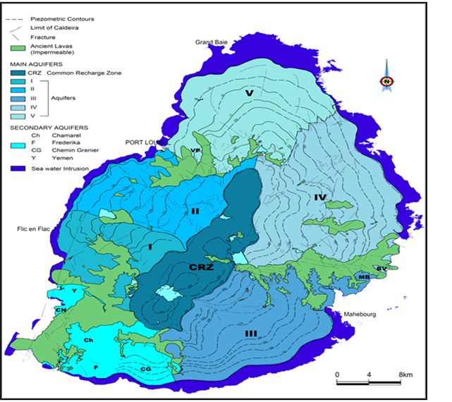 Source: Water Resources Unit Statistics Mauritius: Digest of Environment Statistics Yr2024
Five main aquifers:
Secondary aquifers:
source: MAP - Water Resources Commission |
INDICATORS
Table 53 - Average annual (2001 - 2010) volume of water measured at the flow measuring station on selected rivers4
https://docs.google.com/spreadsheets/d/1e-R_DllgZoaZSWAm-2d1qpG-KOvf2F3d/edit#gid=345857602
https://docs.google.com/spreadsheets/d/1iMeXp19Vh12QLZp9aCSzQ99xxKi9zzHTWy7T6fg87HM/edit#gid=0