
Mauritius and its outer islands, such as Rodrigues, experience a moderate risk of landslides, primarily due to their volcanic origin, which has resulted in hilly and mountainous terrains. The susceptibility to landslides in these regions is influenced by several factors, including heavy rainfall, tropical cyclones, and human activities such as deforestation and land use changes. While Mauritius and its outer islands do face a risk of landslides, the frequency and severity of such events are generally lower compared to other landslide-prone regions globally. Nonetheless, the combination of natural factors and human activities necessitates ongoing vigilance, preparedness, and mitigation efforts to manage and reduce the risks associated with landslides.
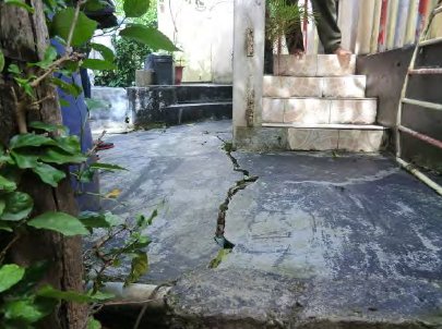
Mauritius has several areas identified as high-risk for landslides, with recent incidents causing significant damage to housing and infrastructure. These events are often triggered by intense rainfall over short periods, exacerbated by factors such as reduced vegetation cover and precarious constructions on sloped terrains or near rivers.
Notable Landslide Events in Mauritius
- Annual Occurrences: Landslides in Mauritius are often associated with the annual cyclone season, which can bring intense rainfall and storm surges from November to April. These conditions often lead to soil saturation, increasing the risk of landslides.
- 1986: La Butte area affected with many houses and a school encountering significant damages.
damaged. Countermeasures were undertaken in 1998 by help of Japan, and it has been stable
since. - February 1996: One of the most significant landslide incidents occurred in February 1996 when Tropical Cyclone Hollanda struck Mauritius. The cyclone's intense rainfall triggered numerous landslides across the island, causing extensive damage to infrastructure, including roads and homes.
- March 2013: Heavy rains led to several landslides in the capital city of Port Louis and other areas, causing traffic disruptions and damage to properties. This event highlighted the ongoing risk of landslides during periods of heavy rainfall.
- The Mauritian government has recognized the risks posed by landslides and has implemented various measures to mitigate this hazard. This includes geological surveys, public awareness campaigns, and engineering solutions such as retaining walls and proper drainage systems to stabilize slopes.
Source: JET, 2015 Landslide Risk Assessment and Management
- Geological Studies: Regular geological studies and mapping are conducted to identify areas with high landslide susceptibility.
- Infrastructure Resilience: Building codes and land use planning are continually updated to improve resilience against landslides, especially in high-risk areas.
- Public Awareness and Preparedness: The government and local authorities conduct public education campaigns to inform residents about the risks of landslides and the steps they can take to reduce their impact.
Landslide-potentiality Index Map
Landslide-potentiality maps indicate areas that are potentially at risk of landslides during periods of heavy or torrential rainfall and cyclones. The inputs to a landslide-potentiality map are typically information from a rainfall map, a slope map, a land cover map, a geological map and a soil map. The LPI map of Mauritius is an enrichment for the already defined landslide prone areas which are those lands that have slope higher than 20°.

LPI Map. R. Nigel and SDDV Rughooputh Geospatial World - 09/01/2009
(The output Landslide Potentiality Index map indicate areas that can potentially slide through interpretation of the indices represented on the map. The lowest and highest indexes (1 & 10) correspond to the lowest and highest potentiality of land to slide and lands with no indexes have no risk of sliding even though such lands can still be vulnerable to sliding lands from uphill.)
Inventory Landslides Areas
High-risk areas include Chitrakoot, Quatre Soeurs, Vallée Pitot, La Butte, Chamarel, and Corps de Garde’s Ridge.
The incidence of landslides has been on the rise; in the late 1990s, only one hazardous site required significant preventive measures, but by 2005, this number had increased to 22.
As part of the “Cyclone and other Natural Disasters Scheme 2011/2012”, 37 sites have been identified, with six specific sites—Laval Tunnels in Palma, Curepipe, Riviere des Creoles, Batellage, Olivia and Kewal Nagar, and Montagne Signaux—designated as risk areas currently under consideration for landslide management plans.
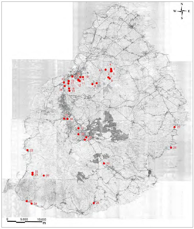
Landslides Inventory Map. Source: JET, 2015