
More data about the population and housing in Mauritius and Rodrigues can be obtained from the Census done by Statistics Mauritius and that can be accessed here.
Population and Vital Statistics | ||
The history of the evolution of the population in Mauritius is a fascinating journey that reflects the island's complex history, diverse cultural heritage, and economic development, and social progress. Over the centuries, the population of Mauritius has undergone significant transformations. The nation's ability to embrace its multicultural heritage and leverage its human capital has been central to its development and continued success.
CLICK ON THE LINKS BELOW TO VIEW THE GRAPHS Population Pyramid (1950 - 2100) Natural population growth rate, 1950 to 2100: The natural growth rate is the population change determined by births and deaths. Migration flows are not taken into account. Projections from 2024 onwards are based on the UN's scenarios (L, M, H) Population density, 1950 to 2100: The number of people per km² of land area. Projections from 2024 onwards are based on the UN's scenarios (L, M, H). Population by age group: Historic estimates from 1950 to 2023, and projected to 2100 based on the UN medium scenario. Sex ratio, from 1950: The number of male population per 100 female population. Birth rate, from 1950: The number of live births occurring during the year, per 1,000 people. Death rate, from 1950: The number of deaths occurring during the year, per 1,000 people. Births and deaths per year, Future projections are based on the UN's medium scenario. Life expectancy at birth, 1950 to 2100: Period life expectancy for individuals who have reached age 0. Estimates are expressed as the expected age at death, not as years left to live. Projections from 2024 onwards are based on the UN's scenarios |
OTHER USEFUL LINKS with MAURITIUS DATA | |
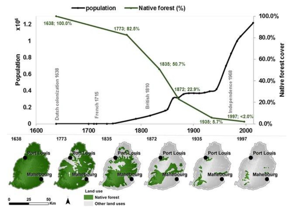
Population growth and Deforestation on Mauritius since human colonization | ||
Pre-Colonial Period and Early Settlements
Dutch Era (1638-1710)
French Colonization (1715-1810)
British Period (1810-1968) and Independent Mauritius
|
 | |
Independent Mauritius |
Independence and DiversityMauritius gained independence from British colonial rule in 1968. The nation comprises the islands of Mauritius, Rodrigues, and Agalega, home to Mauritians, Rodriguans, and Agalegans, respectively. The population is a vibrant mosaic of diverse ethnic groups, including Creoles, Indo-Mauritians, Sino-Mauritians, and Franco-Mauritians. This rich multicultural diversity is evident in the cultural festivals, languages, and traditions that continue to evolve. Socioeconomic Transformation and Demographic ShiftsFollowing independence, Mauritius underwent significant social and economic changes, including urbanization and industrialization. The country diversified its economy from traditional sugar production to sectors like textiles, tourism, and financial services, spurring population growth and urban development. The 20th century saw steady population growth in Mauritius, with efforts in later decades focusing on controlling birth rates. This shift helped the nation concentrate on improving healthcare, education, and socioeconomic conditions, greatly enhancing the quality of life. Education and Healthcare AdvancesInvestments in healthcare and education have contributed to a more urbanized and educated population, underpinning the country's development and helping Mauritius make significant progress in improving living standards. Emigration and DiasporaWhile the population continues to grow, there is also a notable trend of emigration, with Mauritians seeking opportunities abroad. This diaspora is an extension of the island’s community, contributing globally. Urban and Population ChallengesMauritius's high population density, driven by urbanization and limited land area, presents unique challenges in urban planning and infrastructure. The government has actively implemented measures to tackle these issues, aiming to promote sustainability and improve the quality of life for all residents. |
Population Dynamics and Environmental Impact in Mauritius |
Population and Environment InteractionsChanges in population size, composition, and regional distribution are deeply interconnected with environmental impacts. The influence on the environment extends beyond mere numbers; it intertwines with the community's technology, lifestyle, and socio-economic structures. With fixed technology and lifestyle, environmental demands scale linearly with population size. However, this relationship becomes non-linear with increased environmental strain, potentially leading to permanent ecological changes. Mauritius's Demographic ShiftsIn the early 1960s, Mauritius exhibited one of the highest global population growth rates (Suntoo 2012).. A rapid transition saw fertility rates halve from over six children per woman in the early 1960s to just above three by the early 1970s, marking a significant demographic shift. This period of intense social development occurred without parallel economic growth, which only materialized post-fertility decline in the late 1970s and 1980s. Socio-Economic Impacts and Future ChallengesThe current demographic scenario in Mauritius reflects reduced fertility rates, now below replacement levels, contributing to an aging population. This shift has been supported by enhanced access to education, healthcare, food security, and employment opportunities, leading to increased life expectancy. These demographic changes provide valuable insights into the dynamics of demographic transitions and highlight the necessity for strategic planning in healthcare and social services. The balance between catering to the needs of an aging population and the aspirations of younger generations remains a critical policy challenge for Mauritius. |
Settlement Patterns | |
Human settlement patterns in Mauritius are diverse and have evolved over centuries, reflecting the island's history of colonization, economic development, cultural diversity, and environmental considerations.. The unique geography of Mauritius, with its coastal plains, mountains, and fertile plateaus, has influenced where and how people have chosen to live. The diversity of settlement patterns, from urban centers to rural villages, contributes to the unique character of the island and its ability to offer a variety of lifestyles and opportunities for its residents. Much of Mauritius's population is concentrated in urban and coastal areas, particularly in the northern and western regions of the island. The limited landmass fuels high population density, making Mauritius one example of a densely populated country. Some areas even surpass megacities in density (Kaudeer and Venkannah, 2020). The government of Mauritius places a strong emphasis on efficient land use and urban planning to address the challenges posed by population density. This includes measures to control urban sprawl and promote sustainable development. Mauritius has initiated programmes to address population density concerns, with a focus on sustainable development, environmental preservation, and improving the quality of life for its residents. Coastal Much of Mauritius's population is concentrated along the coastal regions, especially in the north and west. The capital city, Port Louis, situated on the northwest coast, is the most populous urban center. Coastal areas are attractive for residential and economic activities, as they provide easy access to the sea, trade, and tourism. Coastal areas are home to numerous hotels, resorts, and tourist facilities. Tourism has led to the development of exclusive and luxury accommodations, particularly in regions like Grand Baie and Flic en Flac. Urban Centers Urbanization is a prominent feature of Mauritius, with several major urban centers, including Port Louis, Beau Bassin-Rose Hill, Curepipe, Quatre Bornes, and Vacoas-Phoenix. These cities are hubs for commerce, government, education, and healthcare. This surge for rapid urbanisation has been driven by better infrastructure, job opportunities, and economic activity. Rural and Agricultural Areas Inland regions and the central plateau are characterized by smaller ‘towns’ like Triolet and Moka, villages, and agricultural landscapes. Whilst much of the flat lands are occupied by sugarcane cultivation, the upper central plateau is known for tea plantations. Residential Neighborhoods Emerging 'Townships' Residential neighborhoods vary, from high-density urban areas with apartment complexes to suburban and rural settings with single-family homes. Each reflects the preferences and lifestyles of different segments of the population. As Mauritius continues to grow and develop, new 'townships' and residential areas are emerging, particularly in response to population growth and urban expansion. Economic Zones Industrial and commercial areas are strategically located, often near urban centers. The Plaine Wilhems region is known for its industrial zones, and it has experienced rapid development in recent years. Protected Areas and Nature Reserves Some regions of Mauritius are protected for their ecological and environmental significance. National parks, nature reserves, and wildlife conservation areas are located across the island. |
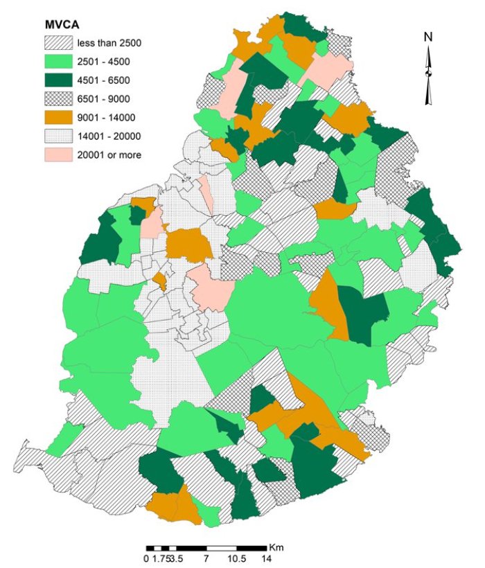
Mid - year population by MVCA - Island of Mauritius 2022 (source: SM (2022))
|