
A Coral Atoll North of Mauritius
Location and Geography
Area
Islands
Climate(Data sources: Government of Mauritius 2005, Mauritius Meteorological Services 2010)
Seasonal distribution:
Population and Economy
Main economic activity
As the island has no natural passes sufficiently large to permit navigation, an artificial pass has been created in the reef of North Island to provide access to the land. Flora and Fauna
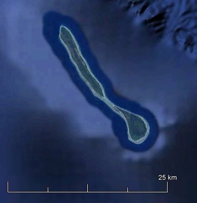
|
source: Google Earth 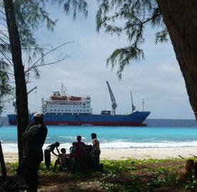 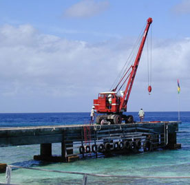 |
With the realization of the two major infrastructural development projects namely, the airstrip and the new jetty, the stage is now set for Agaléga to embark on a transformative journey towards a better and brighter future for the Agalegans and their children.
These projects will go a long way towards improving the air and sea access to the island and contribute significantly to improving the standard of living of our Agalegan brothers and sisters as well as also broaden the scope of economic activities in Agaléga.
In addition, the implementation of these projects will also cater to the future development needs of Agaléga as well as implementation of measures to promote, protect and safeguard our maritime security needs in the following areas, amongst others -
surveillance and monitoring of our vast EEZ of 2.3 million square kilometres,
counter-piracy, counter-terrorism, counter-narcotics and human trafficking;
controlling poaching and illegal, unreported and unregulated fishing,
provision of hydrographic services;
promoting economic development, including blue economy initiatives;
emergency response, including search and rescue,
marine pollution response, and
Humanitarian Assistance and Disaster relief activities.
A Committee at the level of the Prime Minister’s Office is currently working on a Master Plan for the development of Agaléga to look into the following issues:
(i) implementation of mitigation measures against beach erosion;
(ii) protection of historical monuments;
(iii) provision of sports facilities;
(iv) development of fishing;
(v) upgrading of health services;
(vi) boosting food crops and livestock production,
(vii) improving fire and rescue service;
(viii) enhancement of educational facilities;
(ix) improvement of land transport facilities,
(x) improvement of internet and mobile connectivity,
(xi) construction of housing units and maintenance of existing units and staff quarters, and
(xii) employment opportunities and training.